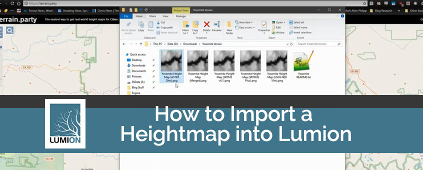
In the world of architectural visualization, Lumion 3D software has quickly become the industry-standard for creating beautiful, photorealistic scenes for your designs. One of the many useful features in Lumion PRO is the ability to import a heightmap into your scene to create realistic terrain quickly. In this post, we’ll look at what a heightmap is, why it is useful, and how to use this feature.
What is a Heightmap?
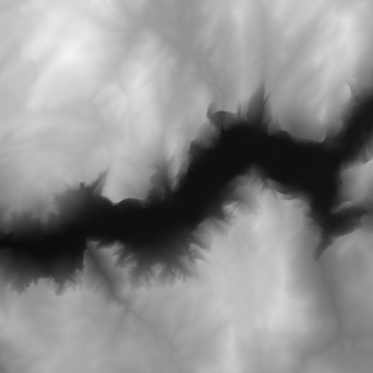
The above image is an example of a heightmap. A heightmap is, essentially, an image that is made up of black and white colors. Software programs that can read heightmaps will interpret the color of a pixel to represent the height of that pixel.
In a heightmap, the whiter a pixel is, the higher the elevation of the pixel. The blacker a pixel is, the lower the elevation of that pixel. As you can see in the above screenshot, there is an obvious valley that is surrounded by mountainous peaks. The above screenshot is a heightmap of the Yosemite Valley.
(Image Courtesy of Wikimedia Commons)
Why Are Heightmaps Useful?
Probably the most obvious reason heightmaps are useful is for creating terrain that resembles an area that exists in real life. In Lumion, photorealism is often the goal, and being able to put your design into the context of the location it will be built is important. With the many tools the USGS and NASA have created, getting heightmaps from real-world locations is easy. One such resource that I highly recommend is a site called terrain.party. Such websites allow you to select an area from an interactive globe and download the heightmap using USGS data. The heightmaps are highly accurate and it takes only a few minutes to get them.
Another reason heightmaps may be useful is so you can easily create your terrain in a 2-dimensional workspace such as Photoshop. Manually raising and lowering terrain in Lumion can sometimes be difficult. Additionally, some people may be more comfortable working with Photoshop. Heightmaps allow you flexibility in how you wish to approach terrain creation for your scene. You will not longer be constrained only to Lumion’s terrain editing tools.
Tutorial Video
This short video will walk you through the process of importing your heightmap into Lumion for use in your projects.
Conclusion
Hopefully, this blog has helped shed light on heightmaps and how to use them. Remember, heightmaps are another tool in your toolbox. You don’t have to use them if you don’t want to. But I do recommend trying them out and seeing if you like them. It could open a whole new workflow for you and enable you to create a more realistic scene for your design. Lumion and Lumion PRO architectural visualization software are both available at Studica. Good luck!
Share this Post